Alder Creek
The City obtains some of its municipal water supply from Alder Creek, a tributary of the Sandy River. The Alder Creek watershed comprises approximately 4200 acres, 3900 acres of which drain to the City’s diversion structure.
|
Owner/Agency |
Acres |
Percent of Total |
|---|---|---|
| Bureau of Land Management | 454 | 11% |
| Longview Fiber Company | 605 | 16% |
| Mt. Hood National Forest | 2630 | 67% |
| Various Private Ownership | 226 | 6% |
| Total | 3915 | 100% |
The City filed for water rights on Alder Creek in 1974 after examining groundwater and surface water sources in the Sandy area. Alder Creek was selected to supplement Brownell Springs after studying Badger Creek, North and South Boulder Creeks and Wildcat Creek. Based on dry weather flow data it was determined that Alder Creek had the greatest amount of water available in a watershed that was composed primarily of government and industrial forest lands. There were no “untouched” watersheds available, (active timber harvests in the Bull Run Watershed were underway in the 1970’s). Since the City intended to build a filtration plant anyway the greater concern was residential development in a watershed, which could be the source of fecal contamination from on-site wastewater systems. A 1.0 MGD (million gallons per day) water treatment plant and associated reservoirs, piping and pump stations were built in 1977.
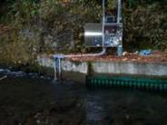
Water Quality Monitoring Equipment at Alder Creek Intake Structure
The water treatment plant and the pump stations were expanded to 2.0 MGD capacity in 1998. In 2001 the 1977 treatment unit was replaced with a more efficient system increasing total plant capacity to 2.6 MGD which is equal to the water rights the City holds on Alder Creek.
Raw water quality is typical of small watersheds on the western slope of the Cascades. pH is usually below neutral and ranges from 6.7 to 7.3 most of the year. Temperature varies from 5° C in the winter to 15° C in the summer months.
Untreated water turbidity (a measure of particulate matter in the water) is generally below 0.25 NTU during the dry season and below 1.0 NTU November through March. As with most small watersheds raw water turbidities spike with rainfall events and recover quickly after rain stops. The highest peaks are associated with rain on snow events or rainfalls greater than 2” in 24 hours where turbidity can exceed 10 NTU. During the February 1996 flood event raw water turbidities in excess of 100 NTU were recorded. Most of the watershed is in the transient snow zone, where rain on snow events have the greatest influence on water quality.
As would be expected for a watershed consisting primarily of resource lands - regulated inorganics, Synthetic Organic Compounds, and Volatile Organic Compounds have not been detected in any of the analyses performed for the City.
In 1997 the City signed a Memorandum of Understanding with the Mt. Hood National Forest and Bureau of Land Management, Salem District regarding water quality issues and future resource management practices. We monitor raw water quality at the intake site. Temperature, turbidity, conductivity, flow and rainfall data are collected on an hourly (or more frequent) basis.
In 2014 the Portland Water Bureau constructed fish pasage improvements on Sandy's diversion dam on Alder Creek. Portland is required to make certain improvements in the Sandy River Basin to mitigate for fish habitat lost when storage reservoirs were constructed on the Bull Run River. This project will improve downstream passage for juvenile salmon and upstream passage for spawning fish.
The DEQ/DHS Source Water Assessment Report for Alder Creek can be found downloaded below, or a hard copy is available in the government document section of the Sandy Public Library.


